When dealing with real estate, land development, or property transactions, two terms often arise: plat and survey. They might seem interchangeable since both involve maps and measurements of land, but they serve very different purposes.
Understanding the distinction between a plat and a survey is crucial for property owners, developers, and anyone involved in real estate transactions. This article explores the differences, similarities, and practical uses of plats and surveys.
Understanding What a Survey Is
A land survey is a detailed, precise measurement of a piece of land conducted by a licensed land surveyor. Its main purpose is to determine the exact boundaries, dimensions, and features of a property through the use of sophisticated equipment such as GPS and laser scanners. This information is then shown on survey plans.
There are four main types of surveys.
1) Boundary surveys – These surveys establish the legal property lines and corners of a parcel.
2) Topographic surveys – These surveys present the contours, elevations, and natural features of the land.
3) ALTA/NSPS surveys – These are surveys used for commercial properties that include boundary, easement, and improvement details. ALTA stands for American Land Title Association. NSPS stands for National Society of Professional Surveyors.
4) Construction surveys – These are used to guide new construction projects by marking proposed building locations and elevations so that a contractor knows how to build the project according to the approved plans.
Surveys are often required in property sales, construction, and disputes involving land ownership or encroachment.
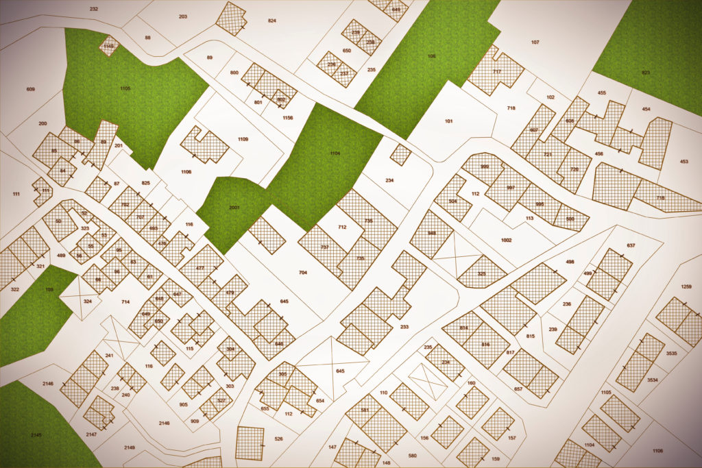
Understanding What a Plat Is
A plat, on the other hand, is a recorded map that shows how land has been divided, typically within a subdivision or development.
Unlike a survey, which focuses on a single parcel, a plat often represents multiple lots or tracts of land and their relation to one another. It is prepared by a surveyor but is primarily used for recording land divisions with the local government.
A plat will typically show the following five items.
1) Property boundaries and lot numbers
2) Street names and right-of-ways
3) Easements for utilities or drainage
4) Public spaces or common areas
5) Dimensions and total acreage of each lot
Plats are submitted to and approved by city or county planning departments before being recorded in public records.
Once recorded, the plat serves as the official map that defines how the land is divided and how each lot can be sold or developed.
The plat establishes how land is planned and legally defined, while a survey measures what is physically present.
Key Differences Between a Plat and a Survey
Although plats and surveys are both prepared by surveyors and relate to land boundaries, their purposes, levels of detail, and uses are distinct.
A plat is designed for subdivision planning and land recording, while a survey is prepared for defining exact boundaries and verifying existing features.
Surveys provide precise, technical measurements of property lines, elevations, and improvements. Plats show a broader overview, such as how land parcels fit together in a subdivision.
Surveys are typically used for individual properties, especially during sales, construction, or disputes. Plats are used for multiple parcels or new developments where land is being subdivided or replatted.
A survey is about precision and measurement, while a plat is about layout and recordkeeping.
When You Need a Plat Versus a Survey
The need for a plat or a survey depends on the purpose of your project or transaction.
You would need a survey when purchasing or selling property, building a new structure, adding a fence, or resolving boundary disputes. Mortgage lenders and title companies often require boundary or ALTA surveys before finalizing a transaction to ensure there are no encroachments or legal conflicts.
A plat would be required when subdividing a piece of land into smaller lots, adjusting property lines, or creating new development areas. Developers would submit plats to local planning authorities to obtain approval before selling or developing lots.
In many cases, a plat and a survey complement each other. A subdivision plat might be created first to outline how land will be divided. Individual surveys might then be prepared for each lot to verify the specific boundaries and features before the land development design and construction begins.
Legal and Practical Importance of Both Plats and Surveys
Both plats and surveys play vital roles in protecting property rights and ensuring orderly development. From a legal standpoint, they provide clarity on where property boundaries lie and how land can be used or divided. This clarity helps prevent disputes over encroachments, easements, and ownership.
Licensed surveyors and government officials are key players in this process. Surveyors ensure the technical accuracy of measurements, while local governments review and approve plats to ensure compliance with zoning laws, building codes, and subdivision regulations. Properly recorded plats and accurate surveys safeguard property investments, prevent costly legal battles, and promote responsible growth.
Conclusion
While a plat and a survey may appear similar at first glance, they serve distinct but complementary purposes in the world of land development and real estate.
A survey defines what exists (the precise boundaries and features of a property) while a plat defines how land is divided and recorded for legal and planning purposes. Understanding both is essential for developers, property owners, and investors alike.
When buying land, subdividing property, or starting a development project, it is best to consult with licensed land surveyors, civil engineers, or real estate attorneys to ensure compliance with local regulations and to protect your investment.