When land is divided into smaller lots for development, one of the most important legal steps in the process is preparing and filing a subdivision plat.
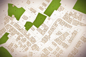
A subdivision plat is a detailed map that outlines the divisions of a tract of land, showing the layout of lots, streets, utilities, and easements. Filing this plan with the appropriate government office ensures the subdivision is legally recognized and that each lot can be sold or developed individually.
Without a properly filed plat, property transactions can face serious legal obstacles, and developers may encounter delays or denials in building permits. This article explains where a subdivision plat is filed and why it matters.
Understanding What a Subdivision Plat Is
A subdivision plat serves as a formal, technical plan that shows exactly how a piece of land has been divided. Created by a licensed land surveyor, it provides detailed measurements, boundaries, lot numbers, street layouts, easements, and other physical and legal features of the property.
Each subdivision plat typically includes the following five items:
1) Lot boundaries and dimensions
2) Street names and right-of-ways
3) Utility and drainage easements
4) Setback lines and common areas
5) Surveyor certifications
It is important to distinguish a plat from a survey. While a survey shows the boundaries of an existing parcel, a plat shows how that parcel has been divided into multiple lots or sections for development.
Recording a subdivision plat ensures that the new lots are recognized as legal parcels, which is essential for selling, financing, or developing the property. A recorded plat is what transforms a private plan into an official part of the public land records.
The Role of Local Government in Plat Filing
Local governments play a major role in reviewing, approving, and recording subdivision plats. Before a developer can file a plat, it most likely will need to go through several stages of review by various municipal or county departments.
Planning and Zoning Departments: These departments ensure that the proposed subdivision complies with zoning ordinances, land-use plans, and density requirements. They verify that the development aligns with local regulations on lot size, frontage, and access.
Engineering or Public Works Departments: These agencies check that infrastructure elements such as roads, drainage, and utilities meet construction and safety standards.
Planning Commission or City Council: In many jurisdictions, the planning commission or local governing body must give final approval before the plat can be recorded.
This process ensures that all subdivisions meet community standards, protect environmental resources, and maintain public safety. Once the plat has been reviewed and approved, the developer receives authorization to file the final plat in the county’s official land records.
Where Subdivision Plats Are Filed
Subdivision plats are typically filed with the county office responsible for maintaining public land records.
This office serves as the official repository for property records, including deeds, mortgages, easements, and plats. When a plat is filed, it is then a part of the permanent public record, available for viewing by anyone who needs to verify property boundaries or ownership information.
The filing location depends on the jurisdiction governing the land. For example, land located within city limits might require filing at the city planning office first before it is recorded at the county level. In rural or unincorporated areas, filing might occur directly with the county recorder or register of deeds.
Once recorded, the subdivision plat receives a recording number or instrument number, which can be used to reference the plan in property transactions or title searches. This ensures that every lot shown on the plat is traceable in public records, protecting both developers and future property owners.
The Filing and Recording Process
Filing a subdivision plat involves several formal steps to ensure that all approvals and legal requirements are met.
1) Pre-Approval by Planning Authorities: Before filing, the developer must obtain final approval from the local planning commission or governing body. This ensures the plat complies with zoning, design, and infrastructure requirements.
2) Surveyor’s Certification: The plat must be signed and sealed by a licensed surveyor who certifies that the layout is accurate and based on a professional boundary survey.
3) Signatures and Notarizations: Developers and sometimes local officials must sign the plat before it can be accepted for recording.
4) Submission to the County Recorder or Clerk: Once signed, the plat is submitted to the appropriate county office along with required filing fees.
5) Recording and Indexing: After the plat is recorded, it is assigned an official record number, scanned into the public records system, and indexed by parcel or subdivision name.
After filing, the recorded plat is something that can be used to create property deeds, calculate property taxes, and establish easements or right-of-ways. Recording the plat officially establishes each lot as a separate, saleable property.
Accessing Filed Subdivision Plats
There are several ways to access plats.
1) In-Person at the County Recorder’s Office: Anyone can visit the local recorder or clerk’s office to view or request a copy of a filed plat. Fees may apply for printed or certified copies.
2) Online Property Databases: Many counties have online record search systems or GIS (Geographic Information System) platforms where you can view and download plats.
3) Title Companies or Surveyors: When buying or selling property, your title company or surveyor can help you obtain a copy of the recorded plat as part of the title search or boundary verification process.
It is important to verify that the plat you are viewing is the official, recorded version, not a draft or preliminary version. Relying on unrecorded plats can lead to boundary disputes or legal complications in real estate transactions.
Having access to the recorded subdivision plat helps property owners understand their lot’s boundaries, easements, and relationships to neighboring parcels. For developers, it ensures compliance with regulations and accurate representation in marketing and sales materials.
Conclusion
Knowing where a subdivision plat is filed (and understanding the importance of that process) is fundamental for anyone involved in land ownership or development. Subdivision plats are usually filed with the county recorder, clerk, or register of deeds.
The filing process provides the legal foundation for property ownership, taxation, and land-use regulation.


