
A topographic survey is a detailed measurement of the elevation and surface features of a piece of land. It captures both natural and man-made elements,…

A topographic survey is a detailed measurement of the natural and man-made features of a piece of land, focusing primarily on elevation and surface characteristics.…

Land subdivision plays a vital role in modern land development and real estate markets. It is the process of dividing a larger parcel of land…
A topographic map is one of the most valuable tools for anyone who needs to understand the shape and elevation of the land such as…

Topography is a fundamental concept in geography, earth science, and land-related professions. It refers to the arrangement of natural and man-made features on the surface…
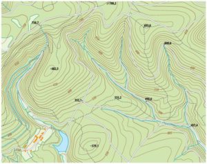
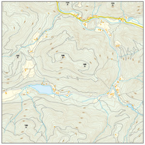
Contour lines are one of the most important features on a topographic map. They provide a visual way to represent the shape of the land,…

Land subdivision is often viewed as an opportunity to unlock value from a large parcel of land, whether for residential, commercial, or mixed-use development. By…
Land subdivision plays a foundational role in how communities grow, properties are sold, and land is developed. At its core, land subdivision is the process…

A land survey of the property that you want to develop is what would be required to prepare an existing conditions plan that would be…

There are many things that go into a land development project to create a plan that can be approved and ready for construction. The following…